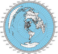
You may prefer the experimental color azimuthal map available here.
Use this form to create an azimuthal map for any location on the globe. You can customize the map in a variety of ways by changing the options in the web form. Report problems or successes as comments on this page.
For PSTRotator recommend 17500 Distance and 8.5" x 11" paper size -- you should be able to zoom the PDF file to shrink down the image close to the PSTRotator size. Then use SnipIt to clip the image into a square, paste into Paint and save as Azimuthal.jpg in PSTRotator/Maps and/or PSTRotatorAZ/Maps.
The location can be a latitude, longitude, a Maidenhead grid square, or a city name (e.g., "51.504572,-0.268225", "IO91um", or "Chicago, IL"). You can indicate North and East coordinates by using a positive number or by adding "N" or "E" after the number. For South and West, you can indicate these with a negative number or by adding "S" or "W" after the number. A Maidenhead grid specification must have two upper case letters followed by two digits and then optionally two lower case letters. For big cities, you can enter just the city name. For other cities, enter the city and state for US cities and otherwise the city and country. The distance is in kilometers. More information on the program is available.
You can help by giving this site a high rating on eHam.net or dxzone.com. The names, locations, and populations of non-US cities were provided by The World Gazetteer. If you have suggestions for improvements or constructive feedback, please leave a comment on the blog.