Someone on the eham.net rating site said, “It would be nice if you could scale up the map to a ‘C’ or ‘D’ size sheet.” I wasn’t sure what to make of this because the map program support about 48 paper sizes (mostly European ISO paper sizes). Well, Wikipedia to the rescue. I’ve added ANSI paper sizes A, B, C, D, and E. Tabloid is a synonym for ANSI B. If there are other common paper sizes that people would like to use, let me know in a comment here.
Month: March 2010
An easier way to get an approximate location
I found a website that can convert an IP address into an estimate of the latitude and longitude of the computer. I added a new button to the azimuthal map form that uses a few lines of Javascript to populate the location field. I am hoping this will provide accurate enough estimates for most people’s maps. The location field is the one that troubles people the most.
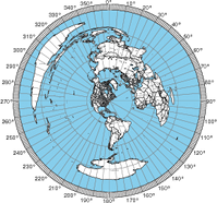
Radial lines every 5° and other improvements
Tom (K8ERV) pointed out that having radials every 7.5° was not very intuitive, so now the map program generates maps with radials every 5°. This spacing makes more sense because the outer ring has major hash marks every 10° and minor marks every degree.
Due to feedback from John Faughn and Tom (K8ERV), I modified the server to set the Content-Disposition header to specify a filename. This resolved various problems
How to post a comment
Just like an email account WordPress blogs are subjected to spam in the form of unrelated and unwanted comments from people trying to get a link to their site. These comments are usually written very generally so they look genuine on every site. I’ve rejected them all because they had nothing related to the subject of the post or this blog in general. I would love to receive comments about this site. However, please make sure that your comments clearly pertain to ham radio or the post/page your commenting on. Your specificity will help me separate your comment from spam.
New QRZ WordPress Plugin
Fixed a bug with small islands
Understanding different forms of locations
The azimuthal map program keeps a log of the parameters submitted and whether the map generation succeeded or not. It does not store or track IP addresses or anything that could link requests to particular users unless you identify yourself in the title. Looking at the logs lets me see how people are using the tool and more importantly how I can improve it.
The location field is the one that seems to trip people up the most, and I have been working quite a bit to expand the range of inputs that will work for the location. For example, you can enter degrees, minutes, & seconds separated by spaces now with a N, S, E, or W to specify the latitude or longitude. You can also use unsigned doubles followed N, S, E, or W instead of using signed values.
Most recently, you can enter city names. For large cities, you may be able to enter just the name. For example, “Chicago”, “Paris”, and “London” resolve to “Chicago, IL”, “Paris, France”, and “London, England”. For smaller US cities, enter the name and the state. For smaller non-US cities, enter the city name and country. This approach only works when the spelling and punctuation match exactly.
ARRL’s International DX contest was cool
Despite having a rather modest rig at my QTH and limited operating time, I am an aspiring contester. This past weekend’s ARRL International DX contest was very cool. I worked a lot of countries that I’ve never worked before. Here is my list of new entities:
- Hong Kong (already confirmed by LoTW)
- Norway (already confirmed by LoTW)
- Sweden (already confirmed by LoTW)
- Honduras
- Chile
- France
- St. Kitts & Nevis
- Germany
- Spain
- Aruba
- Costa Rica
- Finland
- Cape Verde
- Dominican Republic
This is a lot of new entities for me. I am glad that I am finally making it to Europe.
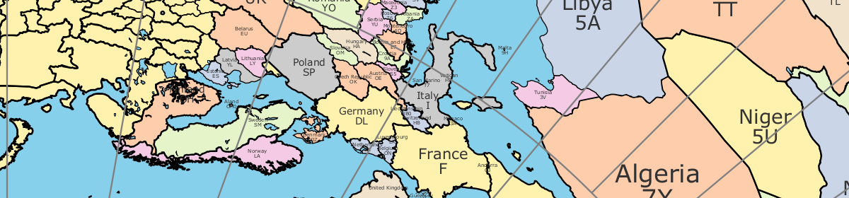
World cities too!
Thanks to the World Gazetteer, the azimuthal map can now display world cities. The database has over 150,000 entries.
Azimuthal map does US cities now!
The azimuthal map form can now add labels for US cities. The database of latitude/longitude pairs for cities seems imprecise because some California cities are in the Pacific ocean. It might also mean that the coastal outlines are not precise enough.
If you notice a city out of place, please let me know. There are some errors in the database. For example, San Francisco was a few miles out to sea.
Update: I updated the list of cities to include ones from Alaska and Hawaii.