Azimuthal map generation is temporarily offline

Ruby Prawn logo
Ruby Prawn’s logo

My web hosting provider upgraded Ruby from 1.8 to 1.9. The upgrade is generally a good thing. However, the upgrade broke the Ruby PDF writer library that my azimuthal map generator uses, so the generator is temporarily offline. I’ve been meaning to upgrade to the new Ruby PDF generator called Prawn for a while, but I haven’t had enough motivation until now.

Right now, most of my energy is directed towards preparing for the ARRL November Sweepstakes SSB contest this weekend. I’ll be on the air from a friends station, so I’ll have a much better score than normal for me. I don’t know if I’ll have enough time to fix the site before this weekend or not.

Special thanks to Johannes (DK5II) for bringing the problem to my attention!
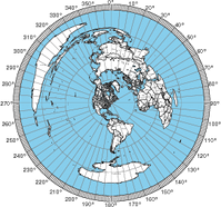
Now with latitude/longitude grids!

I added a new feature to the azimuthal map program to give people the option to add a latitude/longitude grid and Maidenhead grid square labels. This turned out to require an adventure in the world of cubic spline interpolation, but that’s a story for another time. These new features are turned off by default because the map is already pretty dense with information.

More paper sizes

Someone on the eham.net rating site said, “It would be nice if you could scale up the map to a ‘C’ or ‘D’ size sheet.” I wasn’t sure what to make of this because the map program support about 48 paper sizes (mostly European ISO paper sizes). Well, Wikipedia to the rescue. I’ve added ANSI paper sizes A, B, C, D, and E.  Tabloid is a synonym for ANSI B. If there are other common paper sizes that people would like to use, let me know in a comment here.

An easier way to get an approximate location

I found a website that can convert an IP address into an estimate of the latitude and longitude of the computer. I added a new button to the azimuthal map form that uses a few lines of Javascript to populate the location field. I am hoping this will provide accurate enough estimates for most people’s maps. The location field is the one that troubles people the most.

Radial lines every 5° and other improvements

Tom (K8ERV) pointed out that having radials every 7.5° was not very intuitive, so now the map program generates maps with radials every 5°.  This spacing makes more sense because the outer ring has major hash marks every 10° and minor marks every degree.

Due to feedback from John Faughn and Tom (K8ERV), I modified the server to set the Content-Disposition header to specify a filename. This resolved various problems